That's basically been the only "drama" of the whole weather shift lately - is that the temperatures been plunging. And in that regard, SMHI, our tax financed weather service has been right about.
The rain that fell - didn't fall over Stockholm - at least not much. It was in other places across South and Middle Sweden - just not here.
The original low pressure area, basically just passed by Stockholm without its rain touching the city. It was instead the "tail" that the first low pressure area, which has now created a quite powerful local low pressure area - mainly affecting the island of Gotland with stormy winds (gusts up to 19 m/sec), rain and cold weather.
The clouds also affect the capital - so it has been both gusty today, and rather chilly with temperatures around 15-17°C which mark quite a difference compared to the warm hot weather the other days.
Well... that's North European summer.
There isn't anything special about it, really.
Stockholm Vallentuna, June 1941: -6°C (???)
In our weekly local newspaper, i read in an interview about a Swedish weather man called "Weather Nils" - that on 8 June 1941 outside of Stockholm (Ekskogen, Vallentuna**), temperatures had plunged to -6°C early morning.
It surprised me really, because i had never heart about this. Sensational, and on the verge of bizarre.
Now that i think about it deeper, it raises more questions in me... My weather, especially in the past had always been keenly focused on extreme temperatures records in the past. It was exciting, and a way for me to learn to know more about the Swedish weather and extremes. For that i had a special book, which focused on pulling out fantastic extremes throughout times (in the past 150 years).
**) Ekskogen, Vallentuna lies almost half way between Stockholm City an the town of Uppsala.
I remember very well: -6°C early May
in the wider region of Stockholm - where birds supposedly fell dead from the trees. That I had read in a special weather I had bought in the early 90s. (Man, I loved that book and read it likely 300 times) There was no mentioning of -6° in Stockholm region in June.
But it was mentioned for the month of May...
Is that claim even real ?
I see from the archive, that Stockholm City (Observatoriekullen) in the morning of 8 June 1941, registered +1.0°C. The question now is... could the temperature in Vallentuna really have plunged another 7° lower ?
Seems to me sliiiightly hard to believe. Unfortunately, Tullinge station didn't exist. But I can look up Uppsala instead. Well, they reported 0.0°C.
So, why would a station (?) if that even was an official one to begin with, not that far outside of Stockholm, plunge to an extreme -6°C well into June ? Was that even an official station, or a private one ?
I find the value of -6°C extremely suspect. If Uppsala and Stockholm had +1° to 0°C, and consider also this; the night is very short on a 8 June... then it is basically impossible for temperatures to sink to a whopping -6°C in between those places. The airmass that affeected the weather on 8th June 1941 does not support such low temperatures, either.
If that would been an official value, it would been captures in earlier books and records (which often are lifted up here in Sweden; they love statistics).
So no. Sorry. I don't buy it.
Maybe he meant 7-8 May 1941 ?
Now THAT would make sense - because extreme cold air did indeed down over Sweden, where the temperatures plunged to very low values. At the 850 hPa level (1.5 km above ground), it had temperatures down to a whoppign -10°C in North Uppland and Stockholm region !! That would correspond to low temperatures on the ground, as well - absolutely supporting -6°C in an isolated station outside of the cities.
Stockholm City recorded -3.2°C in the morning of 8 May 1941, while Uppsala town reported -3.0°C. Yet on the previous morning of the 7th even lower with -4.0°C.
Now here, i would say, YES, an outlier station like Vallentuna could indeed have reported -6°C, while cities had somewhat higher temperatures, with -4° and -3.2°C.
Like Stockholm-Tullinge station decades later, often was and still is a station that can show very low temperatures in cold weather situations. As do stations like Norrtälje sometimes. And Film, in Northern Uppland.
They are typical "Cold hole" type of stations.
The inflow of ice cold arctic air on 7-8 May 1941 is clearly shown in the following, reconstructed ERA charts below. It was a very strong inflow of bizarre cold air !!
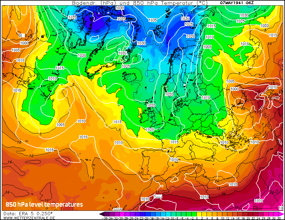
7 May 1941, 850 hPa level temperatures (ERA reconstruction model)
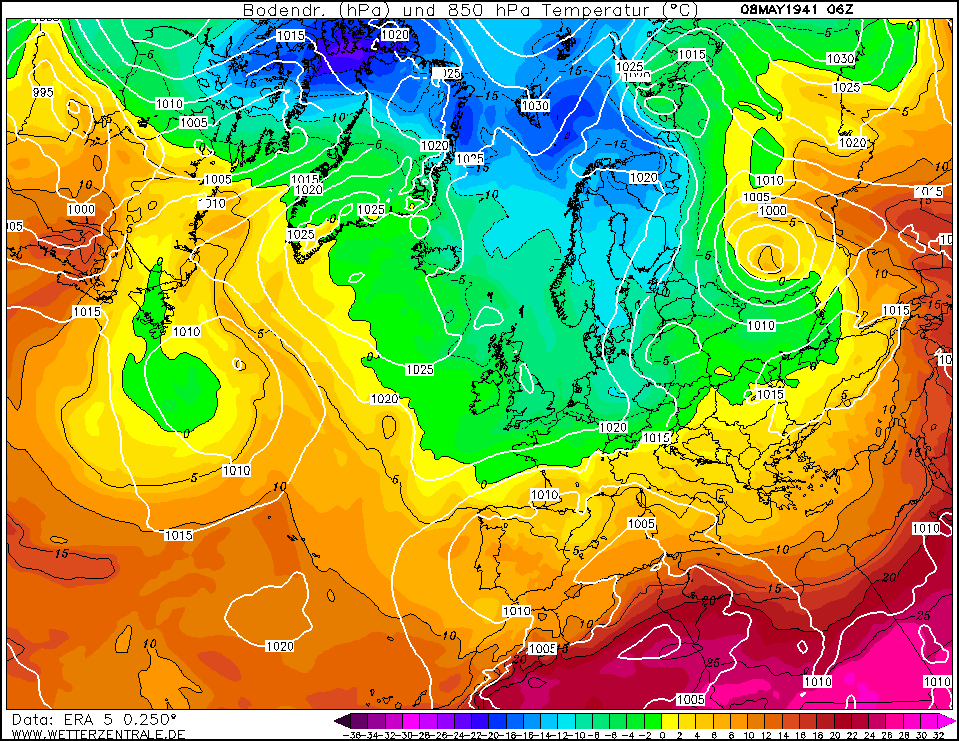
8 May 1941, 850 hPa level temperatures (ERA reconstruction model)
Meh, nope. 8 June 1941
Sure, cold-ish air had seeped into the Uppland region, but there is no mentioning of exceptional low temperatures, neither at the 850 hPa level (maybe -3°C at 1.5 km height).
So, it was an cold airmass, but by no means extreme in any way. Does the 850 hPa chart look extreme ? Not to me. Especially not when compared with 7+8 May 1941 - which showed much, much colder air rolling down.
So, No. The proclaimed -6°C in Vallentuna were not registered on 8 June 1941. Either an error, a false claim or a faulty thermometer.
Sorry, "Nils Weather" Dude.
It's not going to fly.
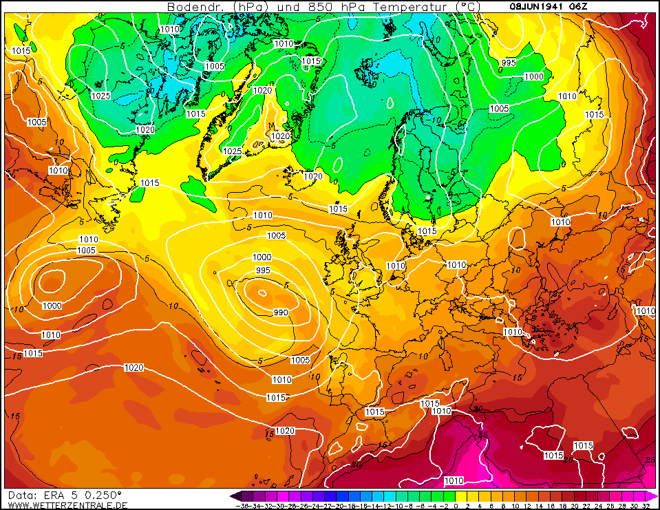
8 June 1941, 850 hPa level temperatures (ERA reconstruction model)
|