|
Stockholm is still residing within a warm airmass, which lead to temperatures up to 31.2°C (in Film & Uppsala) north of Stockholm, and 30.1°C in the city itself. Here in Snösätra we had something like 28.5°C
It is like still being inside a warm pocket
, while a cold front with showers, rain and thunderstorms is about to swoop it all away during the night. Introducing a lot cooler and unstable weather type in the next 10 days. I haven't heard any thunderstorms yet... so perhaps it just all fizzles out.
Albeit the radar shows to me, that there is some action going on, southwest of us in the area between Norrköping and Nyköping (Skavsta Airport). This should soon move over our heads...
We shall see


Looks a bit thin (void of T-storms) in the area that affects Stockholm.
Already fizzling out
The area that affects Stockholm looks rather void of T-storms. The latest radar image from 20.20 reveals to me that it is indeed fizzling out, as the lightning strike activity has shifted, while the one south of us, has diminished. So, it is like a cold front, that has a weak area "in the middle". And that "empty" area is basically passing over the city.
So, likely no T-storms.
This happens quite often when it comes to T-storms and Stockholm. A lively front is rolling in - and then suddenly, the main activity branches into two pieces, while the "inactive" part, passes over the City.
And nothing happens. 
A classic.
Outlook 14 days
I know, it is a stupid headline - because these "prognosis" change every 6 hours - and you'll quickly see that most of it changes after day 5 - predicted anything and everything (bouncing around, unreliably). So, anything beyond day 5 is totally garbage - just saying.

The trend seems to be
a little warmer than what GFS-prognosis model calculated yesterday. Albeit both versions show still unstable weather with some rainfall here and there. In the night of Sunday to Monday, more rain could fall, though. SMHI predicted first 25 mm, early this day 20 mm (and the latest predicts a whopping 33 mm) - while GFS has decreased it down to around 6.7 mm.
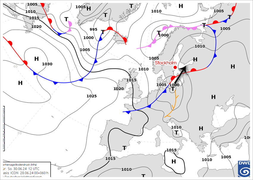
The idea is, that a small but quite lively cyclone moves from Poland across the Baltic sea towards NE, in which the rain area would cover Stockholm. That would - potentially - lead to excessive amounts of rain, given that the cyclone will be fueled by a very warm airmass over Poland.
See illustration below:

From next weekend
according to the American GFS weather model - we might see overall warmer weather. After all, we're shifting into July - so that is the warmest period of the year, and the likelihood of getting 20°C is very high, regardless prognosis. All you need is a little bit of sunshine, and Bam! - you have 20°C. |


