|
When I first wrote about "High Season Summer" has ended in Stockholm... it came from the feeling, that when the nights get a notch or two chillier - high season summer is over. While you still have warm days - but there isn't that "tropical" feeling left at midnight, like during the warmest time, those "few nights", when everything just feels really warm and nice. It is those "warm summer nights" we often tend to think of, when we refer to high season summer though memories.
I should have explained that better.
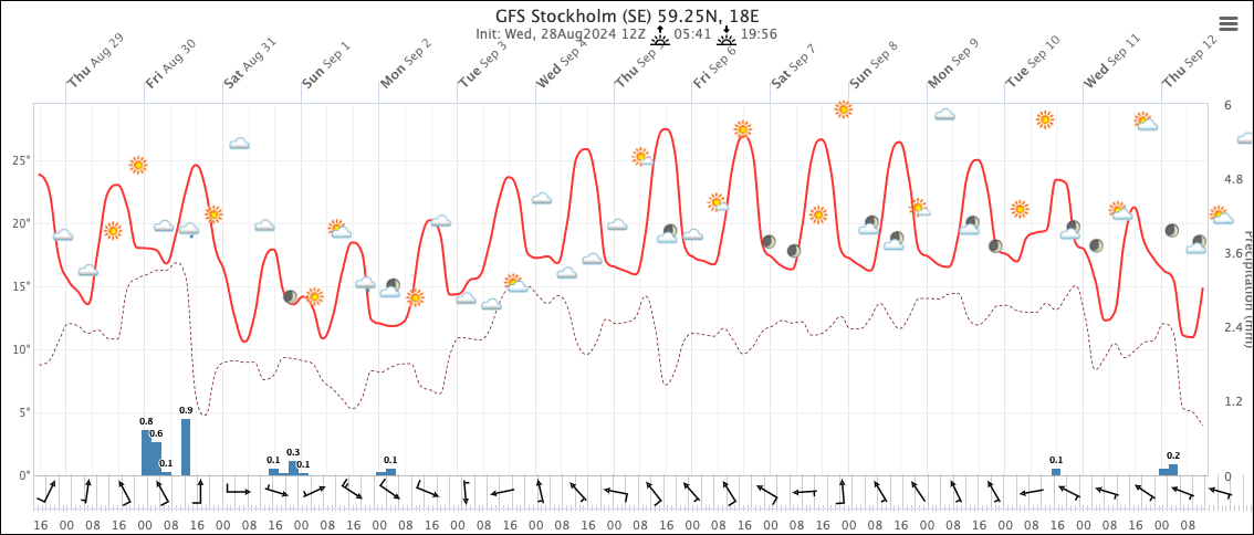
It appears as if GFS has decided to stand with a prognosis version in which the beginning of September, after a cooler, unsteady period we soon face, allowing the Russian anticyclone to reform and move back into our region while also building a bridge over Scandinavia connecting itself to the Azores anti-cyclone. At least so much that it prevent Atlantic as well northern front to penetrate our area, while very warm air gradually get transported to our latitude. This would result into temperatures up to 30°C in Southern Sweden, and perhaps 27°C in Stockholm.
The question is - will it hold up as time moves on ?

Midnight prognosis weather calculation from GFS
shows slightly lower temperatures for Stockholm, a bit more unsteady weather and a somewhat shorter peak period - but still an outlook reminding of an almost high-season summer time; with temperatures close to 25°C, and rather high MIN temperatures above 15°C.

Those temperatures - if they ever comes true
would be pretty respectable high temperatures for September. I wouldn't mind experiencing a little extension of good summer. It may not become truly a "high season summer" type of period, but a prolonging of summer. I hope it holds water.
Again; we shall see, how that comes about.
It should be noted that other weather center calculation models also support the idea of that we first get a small !cold air drop" giving unsteady days ahead, but then the Russian anticyclone creating a bridge connecting all the way with the Azores anti-cyclone, which would stretches up a bit towards western Europe. That anti-cyclonic "bridge" would keep colder / chillier air masses away from Scandinavia, both form the nourth, but also from the west (including rain fronts)
Some models even suggest that this bridge could continue even after 9th september, prolonging a beautiful summer weather type. Albeit i would suspect that close to middle September under high pressure and low air movement - clouds and fog would emerge from the moisture & warm Baltic sea.
Interesting times. |

